
|
Click here to see bigger map
|
|

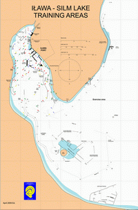
The following training areas are currently available
(see map attached below):
- Mock-ups of harbours with different configuration of entrances and different water depth, turning areas, piers and quays, ferry terminals, docks and locks. Approaching harbours and terminals, berthing and unberthing under various conditions, with wind and current present, entering the lock are the main exercises realised using the above training areas.
- Training areas including straight line and curvilinear waterways and sharp turns. All passages are marked by buoys and leading marks for daylight exercises and a set of navigational lights for night-time exercises. The current generator is also installed in this area.
- Open sea training area, which includes curvilinear depth water canal, sea berths, and a SPM. This area is also used for realisation of standard manoeuvres, rescue and search manoeuvres with taking into account MERSAR recommendations. Ship to ship manoeuvre is very often trained there.
- Shallow water curvilinear canal. This consists of restricted cross-section canal with a bend and straight sections, 140 metres in length. The canal is mainly used for passing and overtaking manoeuvres, slowing down and stopping manoeuvres can also be trained there.
- River training area consisting of curvilinear stream restricted from both sides where current is created. Piers for mooring ship models in current and entrance to harbour basin are installed there.
- Restricted water areas for demonstration bank and shallow water effects (suction force and squat).
|
|
